CCA CRUISING GUIDE TO NEWFOUNDLAND
SPECIAL APPEAL FOR FUTURE UPDATES
The editor of this guide makes a special appeal to all cruisers sailing to Newfoundland - PLEASE keep notes on your travels and send us updated information and pictures to this email: guides@cruisingclub.org Please see the bottom of this page for update submission guidelines.
INTRODUCTION TO UPDATES FOR 2024
A new edition was introduced in May 2023 and is now available at chandleries, nautical bookstores, and online. It incorporates all updates received before March 2023. What follows are updates received after March 2023. Entries are listed with page references to the May 2023 edition of the Guide.
HARBOUR DESCRIPTIONS
Page 42 - Port aux Basques, Southwest Coast
Hurricane Fiona in 2022 did significant damage along this portion of the coast. In July 2024 the floating docks were off limits and in disrepair. The fixed government wharf was also under construction. By contacting the Harbor Supervisor (709-694-2484 or 709-695-7975; pabharbourauthority@gmail.com ) M/V Uhuru was given permission to tie off to a wharf not under active construction. There were multiple cement trucks, storage containers and other items one might expect at a construction site. There was no electricity at the wharf. Conditions will likely improve for 2025; however, it is advisable to contact the Harbour Supervisor for updates.
Credits: Jane Davin, July 2024
Page 44 - Isles aux Mort
In July 2024 the Western Approach marks were absent; but, the Navionics datum seems good through the passage. Navionics datum for the location of the newest and largest public wharf is a little off showing the wharf to the north of its location; it is located just north of the boat ramp at the closed marine service center. The red marker buoy shown on the chart at the end of the wharf is no longer there. Rosita docked on the north side of the new wharf for a week in 2024 and found locals welcoming. There was a small trash can on the wharf; but, no water spigot found.
There is a new wharf project underway in 2024 rebuilding at the site of the old "L" shaped wharf south of town, replacing the one destroyed by Hurricane Fiona in 2022. The Canada Post office remained open; however, the Highway Convenience Store and the Safe Haven Cafe were closed in July 2024. Taxi service was available; although the one provider suggested they would be discontinuing. The local hospital was excellent and did needed x-rays and stitches for one crew member.
The Harvey Trail loop to the east of town is well worth doing. It is being repaired subsequent to Hurricane Fiona damage. The trail is accessed off Cemetary Road, taking a left at the gravel pile before the cemetery, or from where the cafe was on the highway. The visitor center/gift shop beyond the cemetery was closed.
Credits: Michael & Hannah Moore, July 2024
Page 45 - Squid Hole, Southwest Coast
In 2023 a well sheltered anchorage protected on all sides with lots of swinging room. Anchor in 20 feet with good holding in middle of the cove. Narrow entrance has 30 feet at low water. Note that the small, drying island just inside the entrance is obvious at low water but becomes a floating patch of rockweed at high water.
Credits: Martin Fuler, 2023
Page 47 - Rose Blanche
In July 2024 the government wharf in the tickle where the town exists was under construction due to damage from Hurricane Fiona. After docking a boat was asked to leave the wharf and managed to get permission to stay just overnight. With luck, the wharf will be completed for 2025. There is no longer a store, school of tea room; all have closed with the declining population. Canada Post was open for service. In 2024 there was a small lunch spot at the end of the trail to the lighthouse.
Credits: Jane Davin, July 2024
Page 49 - Harbour Le Cou & The Basin
In 2023 Martin Fuller found the approach to either of the two wharves clear and deep in Harbour Le Cou. The outer wharf was showing serious signs of damage and does not look safe. The inner fishermen's wharf had fishing speedboats on long outhauls making it imprudent to attempt approach.
The basin is sheltered from all winds and generally very deep. Access into the Barasway is restricted by the sandbar at the mouth. Anchorage was possible just below the entrance to the Barasway in 33 feet on a rocky bottom; two lines led to shore were used to prevent impact from the stream's outflow and the tide. The water deepen again once past the bar at the beginning of the Barasway with depths of 33 feet off of the waterfall. Rocky bottom throughout.
Credits: Martin Fuller, 2022
Page 54 - La Poile Town Harbour, Southwest Coast
Clear approach but North Cardinal at Naked Man Rock is missing (north of Ireland Island). Final approach marked with small red and green channel markers right into the bay. The ferry arrives at 1730 hours nightly and uses the south side of the wharf overnight with no real room for a yacht to also use that part of the wharf. Not resettled yet.
The main, outside wharf is available for day use. There is a floating pontoon to the west of the main wharf which was full with local fishing boats. There is normally space on the west side of the main wharf with 9 feet alongside. The east side (right as you approach) has apparently been used by a 46-foot yacht and has 8 feet at low water. It offers a very sheltered berth; but, space is very tight. Note the small rocky point on the way in and stay close to the building.
There was a small grocery with limited stock along the footpath to the right towards the church. It is a pleasant community of 60 people; however, th elast child has left the school and it is now closed. No VHF reception and WiFi not available.
Credits: Martin Fuller, 2022
Page 56 - Grand Bruit, Southwest Coast
An appealing old settlement with several families still using it for summer residence in 2023. The church steeple has fallen and the bell is in danger of falling; but, the peddle organ still works. Resettled residents can rent their property back for $1 per year and do maintenance on existing structures. However, new builds are not permitted. The old ferry wharf is still in good condition in 2023 and has 16 feet alongside. The wharf to port has a small floating dock and is used by local fishermen and have haul out lines leading into the bay making approach hazardous for keel boats. In summer 2022 there was a black buoy off the port side wharf which marks the anchor for the floating dock; therefore, do not use it as a turning buoy for the main wharf! The old wharf lies very low and can have waves wash over it, hence best for local fishermen.
The rocky dike protecting the harbour from the east has broken down; but, still bares at low water. Caribou and moose were sighted ashore. Very friendly residents. No VHF reception inside the harbour.
Credits: Martin Fuller, 2022
Page 57 - Cinq Cerf Bay, Culotte Cove, Southwest Coast
The entry around Woody Island is clear; but, give the point plenty of room. Lovely, peaceful and sheltered anchorage with excellent holding in mud with plenty of swinging room in 20 feet. The small stream at the head of the cove provides washing opportunities. Pleasant beach with an otter sighted. No VHF reception.
Credits: Martin Fuller, 2022
Page 61 - Burgeo, Southwest Coast
The route to the MSC has a very narrow final section with small buoys and limited space at the MSC wharf – its pontoons are mainly used by fishermen and access to them is tight. From the East you need to select which option early and either head behind the string of islands into Short Reach or turn to port and follow the buoyed channel to the Government wharf with the advantage of providing quick access to the route out to the west.
The government wharf has space for boats up to 50 feet in front of where the ferries dock. It is free; but, has no services. The Marine Service Center has showers, toilets, laundry and WiFi.
Fuel is only available by jug from Dean (709-886-3324), 2 miles from the wharf. The travel lift is out of service and being dismantled. The Variety Quickstop grocery is a little over a half mile away. The local coffee bar had closed in 2022 The local museum was open in 2022.
Credits: Martin Fuller, 2022
Page 66 - Ramea, Southwest Coast
Phin Sprague reports berthing on the front face of the government wharf. The CSI Harbourview (709-625-2522) is a new restaurant on Main Street and also has two bedrooms to rent. The hardware store has now been incorporated into the back of the local market The trail and boardwalk goes around the island for walking.
Credits: Phin Sprague, September 2024
Page 60 - Connoire Bay, Billiard Cove, Southwest Coast
Beautiful, peaceful anchorage surrounded by low lying hills; one of the best harbours on the south coast. The old rope mooring line across the bay has been removed in 2022. Anchor in 10 feet with three stern lines and good holding. No VHF reception.
Credits: Martin Fuller, 2022
Page 71 - Grey River, Jerts Cove, Southwest Coast
The main settlement is adjacent to the ferry terminal in Jerts Cove. The ferry arrives at 0900 each day. The wharf had no facilities in 2022. The small general store had a limited selection of goods. There is no WiFi service.
Credits: Martin Fuller, 2022
Page 72 - Grey River, Frenchman Cove, Southwest Coast
A very comfortable cove just beyond the settlement. Good holding in 23 feet with swinging room into the cove with 12 feet at low water 100 feet off the grassy beach. No VHF reception.
Credits: Martin Fuller, 2022
Page 75 - Francois, Southwest Coast
Visiting boats were directed to the floating dock with 14 feet alongside, on the far right, just before the last house. The store was open in 2024 and bathrooms were available on the commercial pier on the far left.
Credits: Phin Sprague, September 2024
Page 81 - Facheux Bay, Allen Cove, Southwest Coast
A wide and deep fjord. Allen Cove is found halfway down to starboard. A well sheltered bay. Anchored in southwest corner in 20 feet with excellent holding. The wind was gusting to 24 knots off the hills. The southeast corner shoals rapidly after the 23 foot (7M) mark. No VHF reception.
Credits: Martin Fuller, 2022
Page 81 - Richards Harbour, Southwest Coast - New Entry
General: Well sheltered possible anchorage. Clear entrance with white wooden pyramid on the rocks to starboard. 14-16m through the entrance with 10-12m close to the first island to starboard. Deep bay with 24-32m over most of the bay close-to on all sides except behind the 2nd small island to starboard where the water drops to 7m then 5 and 3m through the gap leading back into the main basin – would be an interesting place to lie with lines ashore. This is clearly used by local lobster fishermen judging by the serviceable lobster pots ashore.
Anchorage: Immediately beyond the 2nd island in the NE corner is a shallow area where it would be possible to anchor with lines ashore. The water shelves from 10m to 5m. Most of the bay is open to the SW but the NE corner (potential anchorage) appears sheltered from all winds and swell. Anchoring would be close in, bow-out with stern lines ashore.
Ashore: Eagles nest on the cliffs and clear signs of current use by a lobster fisherman. No VHF reception inside.
Credits: Martin Fuller, 2022
Page 81 - Dragon Bay, Southwest Coast - New Entry
General: This is a deep, steep sided fjord right to the end where a small cove appears to starboard. Limited space and rocky bottom; would need lines ashore. Main attraction appears to be the high waterfall 1nm in! Either that or some salmon fishing in the river - but that was not tested. The fjord was acting as a wind tunnel with F7 gusts, and we did not stop. There is the potential to anchor in the river mouth at the head of the fjord but with very limited swinging room.
Anchoring: Non found. Not recommended but the river mouth or small bay might be suitable in calm conditions.
Credits: Martin Fuller, 2022
Page 82 - McCallum, Southwest Coast
New 2024 Navionics charts are more accurate. It was noted that the rocky islets do submerge at high water and must be observed. The grocery store remained open serving the 24 full time residents. Lion's Whelp tied to the floating dock which was in excellent condition and had "very deep" water. A payment of $3 was made to the postmaster for the dock space. The wharf under the Blue Diesel tank is very high; but, would be serviceable in a pinch.
Credits: Phin Sprague, August 2024
Page 85 - Great Jervis Bay, Bay D'Espoir, Southwest Coast
In 2022 a clear approach and no evidence of aquaculture in the area. Anchored in sand and gravel bottom in 36 feet with good holding, found after initial attempt dragged, in the NW corner adjacent to Pearl Island near the stream inlet. Anchorage open to winds across the bay.
Credits: Martin Fuller, 2022
Page 85 - Pushthrough, Bay D'Espoir, Southwest Coast
A sagging but still useable wharf. Good cleats on the wharf with 17m alongside. Sheltered wharf but possibly prone to wind funnelling down the Push-Through. The sides of the wharf were broken in places, beware the woodwork could snag on guard rails as the tide rises. There was an unused, circular aquaculture set-up anchored in the Push-Through, but it appeared out of commission and did not hinder mooring.
A delightful spot and easy walk up and around to the old cemetery overlooking the open sea.
Credits: Martin Fuller, 2022
Page 93 - Gaultois in Bay D'Espoir, Southwest Coast
 Easy entrance. There is lots of room on the fish plant wharf even though the plant has been closed for about 20 years. Although deteriorating, the wharf was still feasible for tying up. We first headed for the floating dock, where we landed a spot where clearly someone had made themselves a nest of fenders and lines but were told we could tie up there. The next day the resident boat came back, and we were asked to move, so went to the fish plant wharf.
The Thos. Garland store has closed, but in July, housed a very pleasant art show featuring a local artist. Walking uphill in a northerly direction takes you past the school (now 13 children, used to have 170) and down the hill to the market and another small and very picturesque group of houses.

HIKING Past the market (ask there for directions), find a trail going along the shore out to the grassy areas and the point. It is easy to follow but un-maintained and entails some scrambles on rocks and pushing aside branches.
The hike over to Piccaire (roughly 3 hrs. round trip) was one of the primo walks we have done in Newfoundland -- about 150 meters of vertical gain, nothing too strenuous, mostly trail, some wet bog, some boardwalk. You pass seven particularly beautiful ponds. The last downhill part as you approach Piccaire was not as well maintained but was easy to follow. Reports are that on a still and sunny day, the bugs can be challenging, but on a cool, cloudy morning, we had few. On return, there was a prominent sign pointing inland saying “trail”; do not take it as it is not maintained (probably a winter snowmobile route) but continue straight on the lovely trail along the pond.
Credits: Text and photo by Dick & Ginger Stevenson, August 2019
Chart courtesy of Navionics. Not for navigation.
Page 94 - Little Bay, Bay D'Espoir, Southwest Coast
In 2022 Martin Fuller motoredup Little Bay in thick fog. First bay to port is deep with potential anchorage in 8m but shorelines would be essential and, given the tight space, deployed quickly. The second bay to port is larger and while deep in the middle, offered better anchoring potential; it was a peaceful, idyllic anchorage with another lovely waterfall and a clear approach with good depths to within 10m of the shore. GPS put us ashore when anchored!
Sand and gravel bottom in northwest corner in 8 feet. Needed two lines ashore to prevent swinging. Very sheltered with some local wildlife - an otter and a bald eagle. No VHF reception.
Credits: Martin Fuller, 2022
Page 110 - Grand Bank, Fortune Bay & French Islands
In 2024 Lion's Whelp found Grand Bank to be the easiest port of reentry to Canada after visiting St. Pierre and Miquelon; the phone reporting system offered smooth clearance into the port. It had better services and more to offer than nearby Fortune and proved visitor friendly. Two museums, a restaurant, supermarket, showers and laundry were all within 500 feet of the wharf. Fuel delivery was also available from Atlantic Petroleum either by local phone call or a request through their website.
Credits: Phin Sprague, August, 2024
Page 121 - Ship Cove, Southeast side of Placentia Bay
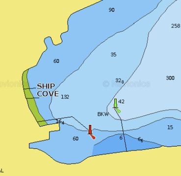 Easy entrance from either outside direction. We expected to anchor in the North Cove (Little Burin Harbor) as we were anticipating a gale from the NE, but we went into Ship Cove for a look-see and were waved onto a fishing boat and helped to moor. This was a lucky happening as Burin is a terrific place to visit. The outer wharf is where fish boats offload but appears to be a good place for a visiting boat to tie up and get sorted.
With the new breakwater, there is good protection inside the harbor from all directions, and we weathered the gale comfortably. The friendly and helpful harbormaster, Marguerite, is there in the mornings. A washer and drier, toilet and shower are located in the building on the hillside of the harbor–go up the outside stairs to the second floor to the red door (always open) and walk to the far end. No cellular on our phones, but the blue house just on the left before leaving the harbor has a small cellular antenna in it that can be used on their porch if no one is inside to let you in. The Harbour internet was usable, depending on one’s location. Please note: in the far corner of the harbor is a constantly running hose with spring water where many locals come to fill their jugs.
There is a nice museum about a 15-minute walk (out the driveway and to the right), which also has a Heritage house that is well set up to visit. Ask for a tour to get the details about the 1929 tsunami, Al Capone, and the planned marijuana greenhouse in the old fish plant. Next door to the museum is a café with good food. Both grocery stores have closed. Look up to find a bright blue VW bug perched high on the rock with a turnkey on its stern and moose antlers on the front (also a ship model).
If you can wangle a car or truck (there is an Enterprise car rental dealer somewhere close-ish at hand, I believe), the driving in almost every direction is marvelous -- the more remote choice of roads, the better. There is a tidal wave memorial a few miles away.
HIKING We hiked up to Cook’s Lookout (CL), which is marked by the large pole on the hill to the North of the marina. We took a shortcut up the backside (no trail) from the cemetery past the church near the wharf. It took 30 minutes and had gorgeous views from the top. We came down by the trail, which was one of the loveliest in Newfoundland. If going up via the trail, leave Ship’s Cove and take a right on the road heading to the museum/café and then a left at the intersection just before the museum. Walk about a ½-mile to an exhibition hall (former school), take a left, and go straight up the hill till you see a sign for the trail to CL. The trail is well-marked and quite easy-going, probably 45-60 minutes to the top. In 2019 they were adding stairs and boardwalks.
Just off the road from the harbor to the left (look for a sign on the side of the road) is a hike up and over Man O’War hill to the next bay where the United Church is located that is so prominent upon entrance to the harbor.
Up farther on the road to the left from the harbor is Jerry Cheeseman’s lookout, another terrific view.
Also, the RC Cemetery on your way to the museum is newly refurbished and worth a wander around. Historical placards are planned. Also, just beyond the church across the street, in the woods, are numerous very old graves interspaced in the trees, many only marked by re-bar crosses, unique in my experience and worth a visit.
Burin is one of the more lovely and special places we have visited. Just gorgeous.
Credits: Dick & Ginger Stevenson, August 2019. Chart courtesy of Navionics, not for navigation
Page 133 - Valen Harbour, South Coast & Placentia Bay
In 2024 Jim Watson reports the harbour remains beautiful and protected. However, be aware that there are no longer any entrance buoys. Also note that there are now extensive aquaculture operations in St. Leonards, the bay southwest of Isle Valen.
Credits: Jim Watson, August 2024
Page 143 - Argentia, South Coast & Placentia Bay
Argentia remains highly commercial and full of construction that make it unfriendly for sailors. Jim Watson recommends exchanging crew by the Argentia Ferry by using nearby Fox Harbour (see page 142). Both Argentia and Fox Harbour are about an hour and a half from St. John's by car. Another alternative with no services is the deep, winding Shallaway Cove.
Credits: Jim Watson, August 2024
Page 144 - Placentia, South Coast & Placentia Bay
Jim Watson reports in summer 2024 that the recently installed lift bridge at the entrance is still prone to getting stuck and recommends against entering. One can anchor in the outer bay and dinghy ashore for groceries at the Foodland. However, it would not make for a good overnight anchorage.
Credits: Jim Watson, August 2024
Page 145 - St. Brides, Southeast side of Placentia Bay
 Easy entrance and tied to the gov’t wharf with power. Glenn, the harbormaster, is quite helpful. There were many fishing boats in this area that is once again rich in cod. No cell service or Wi-Fi. The market up the hill has Wi-Fi (password, “kyleisgreat”). There is a restaurant, The Bird’s Eye, another ¼-mile down the street (had lunch there and it was very good) as well as a cemetery out on the point worth a visit. Brendan Daly (709-337-2401) lives locally and gave us a ride to the bird sanctuary, about 20 minutes away (we called from the harbor office phone; there is also a pay phone in the convenience store). The bird sanctuary was amazing: very worth the effort to get there. Getting back is no problem as it is easy to get rides from out of there.

Gannett nesting sanctuary near St. Brides
Credits: Text and photo by Dick & Ginger Stevenson, August 2019
Chart courtesy of Navionics. Not for navigation.
 GOOSE COVE, NORTH SIDE OF HARE BAY – A very pretty town just south of St. Anthony. We tied up to the wharf and took a lovely walk around town and out to the point where there were well-delineated trails. Electricity was not functional on the wharf, and it was busy with fishermen bringing in cod, so we went out and anchored for the night. We were given a cod by a boat that was getting its catch weighed by a fishing inspector.
Credits: Dick & Ginger Stevenson, August 2017. Chart courtesy of Navionics, not for navigation
CCA CRUISING GUIDES – CRITERIA FOR HARBOUR SUBMISSIONS & UPDATES
HARBOR DESCRIPTIONS – WHAT EDITORS WANT
- OVERVIEW of harbour -- the key factor(s) that make it worthy of consideration
- LAT/LON and local chart number
- APPROACH to harbour identifying buoys, landmarks, ranges, any dangers that could help make a safe entry in limited visibility
- ANCHORING/DOCKING options with details, including depths (at MLW). If a harbourmaster is in charge, please provide details and contact info. Also, the degree of protection from wind and wave action
- FOR THE BOAT – describe facilities including water, fuel, electrical hookups
- FOR THE CREW – showers, laundry, groceries, restaurants, museums, car rentals, taxis, etc. Plus, nearby places of interest to visit, such as hikes or natural phenomena
- ADVICE – any special recommendations – for or against
- HISTORY – local stories and history of significance
- ALTERNATIVE ANCHORAGE(S) NEARBY (if appropriate)
- UPDATES – anything that corrects info in the current edition of the guide.
- SKETCH CHARTS (carefully drawn with as much detail as possible) for areas where existing charts do not exist or accurately portray the harbour’s characteristics
- PHOTOS that:
- Provide useful perspective of features not obvious from existing charts, such as the location of docks or the best place to anchor
- Are beautiful shots that make the area and your boat look appealing
We realize that’s a lot of detail. For many harbors, only some of these factors will apply.
CCA CRUISING GUIDES – CRITERIA FOR PHOTOGRAPHY
QUALITY
- High-resolution images at 300 dpi with a minimum frame dimension of 4 x 4 inches – larger sizes preferred
- Unadjusted/retouched images in JPEG, TIFF, or RAW file types. Others may be possible
- The relationship between digital image pixels and maximum print size is as follows: 600 x 900 pixels = 2 x 3 inches; 1200 x 1800 pixels = 4 x 6 inches; 2400 x 3000 pixels = 8 x 10 inches. The more pixels a photo has, the better the clarity will be when printed.
- If an Apple user, please be certain files are JPEGs or TIFFs that are Windows and PC compatible
SUBJECT MATTER
- Harbor/village shots that help readers understand “the lay of the land” and water
- Approach and entrance with important identifying marks, rocks, unusual land features or lighthouses
- Dockage or wharves where available
- Where to land to get ashore
- Town or waterfront area (harbormaster’s office, fuel depot, shops, etc.)
- Anchoring area(s) with protection from seas and winds
- Overview shots from a high hill or drone are particularly welcome
- Beauty shots that add to the allure of area or province depicted, all well-lit (ideally with sunrise or sunset colors)
- Sailboats under sail or anchored in especially beautiful settings*
- Ditto for power cruising boats.
- Wildlife shots, including whales, seals, seabirds, etc.
- Shoreside flora and fauna
- Interesting people when there is a story to be told
- Icebergs (for Newfoundland and Labrador)
* These shots will be considered for covers and will need to be 8 x 10 inches at 300 dpi or larger
CREDITS
- All photos will be credited to the photographer owning the copyright
- Photos submitted must be your own, or you must obtain the photographer’s written permission.
DELIVERY
- Via email to the respective editor for individual files or guides@cruisingclub.org
- Upload multiple photo files to Dropbox using a public guide specific link such as:
https://www.dropbox.com/request/mXPmIwQaHNKwPvEfsMRQ?oref=e
NOTE ABOUT VIDEOGRAPHY: Video files may also be welcome under certain conditions. Please contact the CCANP Publisher at guides@cruisingclub.org
Information Utility for Newfoundland’s Coastal Mariners: The Coastal Marine Informatics (CMI) Website
CMI consolidates web-accessible information from a variety of sources to support the activities of Newfoundland’s coastal mariners. Special CMI editions have been created for owners of the 2020 edition of the Cruising Guide, along with a downloadable tutorial applicable to this edition. CMI supplements a Guide’s content with information from other sources (e.g., The List of Lights, Buoys, and Fog Signals, marine district climatology reports, etc.) and extends a Guide’s currency with localized, real-time information (e.g., current weather conditions, met-ocean data from Internet-connected ocean observation systems, etc.). Please note that CMI is a non-commercial, continually evolving, experimental facility for planning and informational purposes and is made available to all its users with the usual 'not-to-be-used-for-navigation' proviso. http://iprox.mi.mun.ca/CcaNewfoundland and a special tutorial may be found here: http://iprox.mi.mun.ca/CcaNfldTutorial.pdf