Voluntary Vessel Reporting: Stay Safe(r) When Headed South
“Safety Moments, presented at CCA Stations and Posts”
By Paul Bushueff, Buzzards Bay Post, Boston Station
The Ocean Posse, a community of more than 1,500 long-distance cruising sailors, announced a new cooperative voluntary reporting arrangement with the U.S. Southern Command (SOUTHCOM) designed to improve safety and reduce the risk of misidentification for private recreational vessels transiting high-risk areas of the Eastern Pacific and Caribbean.
Recommendations:
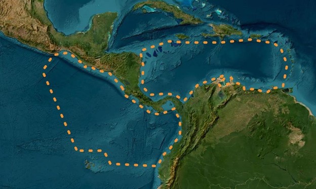
Captains of Vessels making passage in international waters (i.e. more than 12 miles offshore) in the Eastern Pacific south or east of Huatulco, Mexico and north of Ecuador and in the Caribbean south of the Caymans, Jamaica, Puerto Rico, USVI AND BVI and north of South America are recommended to do the following:
- Update the ‘vessel wiki’ for your vessel on www.marinetraffic.com with pertinent vessel details and photos of your vessel to aid in identification (you need a free account to do so). Photos with people on deck (for scale) and from a higher angle (as if sighted from an aircraft or large ship’s bridge) are best. The US military has been informed that this is an open source or crowdsourced platform for vessel identification and contact information.
- File a float plan 72-48 hours before departure. Complete the float plan found at https://floatplancentral.cgaux.org/download/USCGFloatPlan.pdf (please fill completely and use blank spaces in ‘waypoints’ sec on for any Freeform data you wish to include). Send the completed float plan to southcom.miami.scj79.mbx.humanitarian- notification@mail.mil with ‘Float Plan’ and your vessel name in the subject line. If you change plans (departure time, destination, waypoints, etc.) underway, file a new float plan.
- After arrival/completion of your float plan, email southcom.miami.scj79.mbx.humanitarian-notification@mail.mil to advise, with ‘Float Plan Complete’ and your vessel name in the subject line.
When underway:
- Maintain a careful watch 24/7.
- Monitor VHF 16 24/7.
- If available, transmit on AIS 24/7 (note, warships usually do not broadcast on AIS).
- Fly your national ensign.
- If a warship is sighted, hail them on VHF 16. (Warship in vicinity [lat, long] this is the vessel [vessel name, number of persons on board] on innocent passage from [port of departure] to [destination port]). Do not expect an answer, they may be observing radio silence.
- If hailed, respond immediately and follow all instructions.
- Stay at least 100 yards away from any U.S. Navy or Coast Guard ship and slow to the minimum speed to maintain headway if within 500 yards. Adjust your course to ensure your Closest Point of Approach (CPA) always exceeds these values.
- If you have signal flags, you can fly the hoist: “Uniform - Victor - One” which means “I am conducting innocent passage in the territorial sea”. There is no equivalent for international passages, but they will understand the intent of the signal.
For telephone hotline contact (for you and your shoreside contacts), note and share the contact details of:
For the Caribbean:
- JRSC San Juan (Sub-Center of JRCC Miami), Sector San Juan, San Juan, Puerto Rico.
(Caribbean Sea.) - Phone: (833) 453-1267 and/or +1 (787) 729 6770.
- Email: ssjcc@uscg.mil
For the Pacific: